Today my friend Adam was supposed to join me on a 20 mile run so I could show him the Powerlines that I regularly train on. He called me early this morning and told me that he wasn't going to make it because his alergies are really acting up and he's sick. So I decided to take my new camera along and take pictures so I could show him what he missed. I get asked so many times what I think about on these long runs. I have a hard time answering that question without somebody being there seeing what I'm seeing. So today I present a photo essay of my morning run.
The surface consists of nice soft trails to...
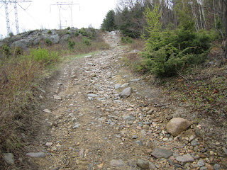
 ...lots of rocks and mud. Facebook friends of mine will remember that 3 weeks ago I posted a picture of my knee blown up from where I slipped on this trail. This is the spot where that happened. The big rock on the left is the one I smashed my knee into.
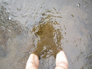
 Much of this trail is ankle deep water with no way around.
 3.5 miles into the run the trail crosses a dirt road and starts to go up. The steepest part of the climb is a half mile and this is where I do my hill repeats.
 Nice soft trail. In the summer this part is covered with wild flowers. What you can't really see in this picture is how steep it is.
 This is where it really starts to get steep. Its not so steep that you have to walk, but it is about as steep as I can go while still running. Perfect training.
 This section is 4 miles in. Is is ankle deep mud that leads to a long waterhole.
 Nowhere to go except strait through it.
 It is so cold it is hard to get through it.
 You crest a hill after the water hole and then it goes downhill to this section.
 This goose was screaming at me. I'm guessing that there were little ones around.
 At 4.85 miles you cross this class 6 road. Lets take a side trip.
 Look up in the trees. There is part of a large tree about 20 feet up. Result of the windstorms that we had a few months ago.
 A little ways up the road there are remnants of a front yard. There are steps going to nowhere.
 And an old well.
 I had to peek. I was bummed to see a beer can at the bottom.
 I don't know much about old houses, but I think this was part of the foundation. I love imagining what it might have looked like when it was there. How long ago, I wonder?
 The first time I explored the area I found this ammo box under a rock. I was freaked out that it was there and then I noticed that it had a NH geocashing website written on it so I had to peek inside to see what it was all about.
 I wish that I had brought something to put in! Of course, I left everything exactly as it was.
 I head back down the road and jump back on the powerlines. Not long after I have to cross this mess. It is knee deep and the bottom is full of soft sand. It fills my shoes with mud.
 A little after the 7 mile mark there is a snowmobile trail that runs parallel to the powerlines. Its nice to change up the terrain. As you can see, it is as wet as the other trails.
 The trail dumps out back onto the powerlines where its time to climb again.
 I know that there is nothing I can do to get prepared for Leadvilles altititude, but this steep rocky trail is about the best training I can do around here.
 More powerlines, as far as the eye can see. I'm heading over that ridge in the distance.
 At 10.5 miles in, I run through a farm. There is a horse who could care less about me and these sheep.
 After the farm, I run another .5 mile then turn around and head back. This is the view from the other way. This is at about the 12 mile mark. I stopped taking pictures because I ran the next 6 miles at marathon pace per my sadistic coaches demands. It feels good to open up the legs and breath heavy after stopping so many times to take pictures.
 This is the view from the top of the steep hill where I run my hill intervals on the way back. Once last summer I was sprinting down this hill when I saw a bear running through the brushes on the right. I was flying and only saw a flash of black fur to my direct right, about 15 feet in front of me. If he kept going we would have collided. Luckily I startled him and he stopped in his tracks and turned. I have never run so fast in my life as I ran down that hill. If I had hit him he would have killed me. Scary stuff.
Below is a map of the run. Sorry the blog layout cuts it off, but if you click on the "view details" link at the bottom right you will go the full page showing the elevation, pace, map, etc for the run. I ended up running the 20.1 miles at a 9:06 pace. Not bad considering that I did the same run on Thursday! Hope you enjoyed coming on my run with me. Thanks for reading.


